Thanks to Nicholas Carr’s great blog, Rough Type, for pointing me to Justin O’Beirne’s 2015 essay “The Universal Map,” which I missed last year. It addresses the quietly seismic changes occurring in cartography. The romance of the profession, formerly an often solitary and painstaking thing, has been replaced by (almost) real-time, computerized efficiency, or so it would seem.
So much of the next wave of AI and automation will demand insta-maps communicated from gadget to gadget and constantly updated (think driverless cars). That means maps will become increasingly universal as smartphones continue to spread. Mistakes will still sneak though most likely, and I suppose they’ll become universally accepted as well. Even if those flaws are corrected relatively quickly, they might cause problems for a brief spell. That at least is the best-case scenario.
As Carr notes, the map itself is being disappeared as tiny bits of information and directions obliterate the larger picture. O’Beirne himself is less sanguine on the topic a year later, writing that the work of Google Maps has surprisingly deteriorated. Is it more troubling to have one mediocre map for all of us than plenty of different ones of varying quality?
O’Beirne’s 2015 opening:
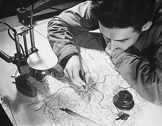
Just thirty years ago — and for most of human history — a cartographer would make a map, print and distribute it, and hope that maybe a few thousand or so people would ever use it before it went out of date. Apart from a handful of atlases and classroom maps, most maps had small, local audiences, went out of date quickly, and were often difficult to read and understand — let alone share.
Fast forward to today, and cartography has since undergone a number of profound changes:
- An unprecedented level of detail is now available to the average person, for little or no cost. The same map literally shows every human settlement in the world at every scale, from the world’s largest cities to its tiniest neighborhoods and hamlets. Every country. Every city. Every road. All mapped in exquisite detail. Moreover, maps increasingly show every business open today — an interactive, visual yellow pages for the whole world. And add to that imagery, street view, and live transit and traffic. No one has ever had access to this much detail, for so cheaply, until now.
- Maps are now always up to date. Errors are corrected in hours and minutes, instead of months and years — and new roads and businesses are added instantly. Unlike the paper maps of thirty years ago, today’s maps never expire.
- Maps fit us, regardless of who or where we are. Foreign lands are presented in our own language, and we can easily and endlessly adjust scales, orientations, dimensions, and even time. We have day mode, night mode, and even basic personalization. And every corner of the globe is presented in the same style, and every map feature is made to be so intuitive, that there’s never a need for a map key. (Google and Apple Maps don’t even have one.) Thirty years ago, we adjusted ourselves to maps; now, maps adjust to us.
- Maps are integrated with robust search & routing. No more looking up the coordinates of an obscure town or street in a map index. No more sitting down and painstakingly planning routes before you leave. Find any place in the world in milliseconds. Calculate any route — be it by walking, driving, or even flying — with unprecedented ease.
- Advanced sensors keep us apprised of our current location, 24 hours a day.Now, we’re never lost.
These are all profound technical changes, 10x improvements that are hugely impactful in their own right. But there’s an even deeper, more profound cultural change seemingly on the horizon:
FOR THE FIRST TIME IN HUMAN HISTORY, THE MAJORITY OF THE WORLD MIGHT SOON BE USING THE SAME MAP.
Think of how deeply profound this is.•
Tags: Justin O'Beirne